Log in
All resources
Create a design
10,904 Free Images of Engraved Maps
copper engraving print
british library
joan blaeu
atlas maior, vol 5 (england) - joan blaeu, 1667 - bl 114.h(star).5
baroque
engravings of topographia braunschweig lüneburg
1667 maps
eran laor cartographic collection
maps from the earth and its inhabitants, vol. iv
maps from the earth and its inhabitants, vol. xiii
atlas maior, vol 5 (england) - joan blaeu, 1667 - bl 114.h(star).5
17th-century maps of cumberland
atlas maior, vol 5 (england) - joan blaeu, 1667 - bl 114.h(star).5
17th-century maps of berkshire
atlas maior, vol 6 (scotland and ireland) - joan blaeu, 1667 - bl 114.h(star).6
1667 maps
atlas maior, vol 9 (italy) - joan blaeu, 1667 - bl 114.h(star).9
1667 maps of italy
atlas maior, vol 7 (france i) - joan blaeu, 1667 - bl 114.h(star).7
1667 maps
atlas maior, vol 5 (england) - joan blaeu, 1667 - bl 114.h(star).5
17th-century maps of surrey
atlas maior, vol 3 (germany) - joan blaeu, 1667 - bl 114.h(star).3
17th-century maps of silesia
atlas maior, vol 9 (italy) - joan blaeu, 1667 - bl 114.h(star).9
1667 maps of italy
charts and maps of the royal museums greenwich
1777 maps
engravings of topographia braunschweig lüneburg
baroque
eran laor cartographic collection
john cary
maps of the kingdom of kongo
maps by petrus bertius
latin-language maps
german renaissance
maps by nicolaes visscher i
atlas van der hagen
topographia franconiae (merian)
baroque
topographia braunschweig lüneburg (merian)
engravings of hannover
map of the german empire by louis stanislas d'arcy de la rochette
1782 maps of the holy roman empire
engravings in the yale center for british art
nathaniel whittock
atlas maior, vol 5 (england) - joan blaeu, 1667 - bl 114.h(star).5
17th-century maps of wiltshire
atlas maior, vol 9 (italy) - joan blaeu, 1667 - bl 114.h(star).9
1667 maps of italy
atlas maior, vol 11 (asia) - joan blaeu, 1667 - bl 114.h(star).11
1667 maps
atlas maior, vol 3 (germany) - joan blaeu, 1667 - bl 114.h(star).3
17th-century maps of silesia
atlas maior, vol 5 (england) - joan blaeu, 1667 - bl 114.h(star).5
17th-century maps of cardiganshire
atlas maior, vol 6 (scotland and ireland) - joan blaeu, 1667 - bl 114.h(star).6
1667 maps
atlas maior, vol 5 (england) - joan blaeu, 1667 - bl 114.h(star).5
17th-century maps of hampshire
atlas maior, vol 5 (england) - joan blaeu, 1667 - bl 114.h(star).5
17th-century maps of berkshire
atlas maior, vol 5 (england) - joan blaeu, 1667 - bl 114.h(star).5
17th-century maps of kent
atlas maior, vol 5 (england) - joan blaeu, 1667 - bl 114.h(star).5
17th-century maps of county durham
atlas maior, vol 5 (england) - joan blaeu, 1667 - bl 114.h(star).5
17th-century maps of cornwall
atlas maior, vol 5 (england) - joan blaeu, 1667 - bl 114.h(star).5
17th-century maps of norfolk, england
atlas van der hagen (volume 4)
atlas van der hagen
eran laor cartographic collection
pierre françois tardieu
a voyage to abyssinia, and travels into the interior of that country, executed under the orders of the british government in the years 1809 & 1810
john outhett
old maps of narva
1700 maps
maps of paris from bibliothèque nationale de france
dheulland map of paris
grigory anikiyevich kachalov
mikhail makhaev
hoogheemraadschap rijnland map, 2nd edition, 1687
linen
david rumsey historical map collection
1790s maps of the holy roman empire
baroque
sickte
eran laor cartographic collection
pierre françois tardieu
copper engravings in the universitätsbibliothek salzburg
wolf-dietrich-klebeband städtebilder
hoogheemraadschap rijnland map, 2nd edition, 1687
gemeenlandshuis zwanenburg in art
celeberrimi fluvii albis nova delineatio by willem janszoon blaeu
old maps of germany from deutsche fotothek
16th-century maps of ireland
copper engravings
alessandro baratta
old maps of genoa
17th-century engravings
johannes de ram
16th-century maps of ireland
copper engravings
engravings of topographia braunschweig lüneburg
baroque
engravings of topographia braunschweig lüneburg
baroque
maps from the earth and its inhabitants, vol. viii
1870s maps of india
maps from the earth and its inhabitants, vol. iv
topographic maps of ireland
maps from the earth and its inhabitants, vol. vii
1878 maps of asia
maps from the earth and its inhabitants, vol. xiii
maps indicating exploration
maps from the earth and its inhabitants, vol. iii
1870s maps of belgium
maps from the earth and its inhabitants, vol. xiii
maps of telegraph lines
maps from the earth and its inhabitants, vol. v
1870s maps of norway
maps from the earth and its inhabitants, vol. iv
topographic maps of the united kingdom
maps from the earth and its inhabitants, vol. iii
linguistic maps of the balkans
maps from the earth and its inhabitants, vol. xvi
1870s maps of panama
maps from the earth and its inhabitants, vol. ix
maps indicating exploration
maps from the earth and its inhabitants, vol. xiii
maps of weather and climate of south africa
maps from the earth and its inhabitants, vol. v
1870s maps of russia
maps from the earth and its inhabitants, vol. vi
maps of weather and climate of asia
maps from the earth and its inhabitants, vol. ix
1870s maps of jerusalem
maps from the earth and its inhabitants, vol. iv
old maps of the lake district
maps by emanuel bowen
brixton, london
wanderings, south and east (1882)
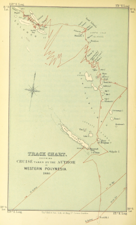
old maps of polynesia
maps by emanuel bowen
brixton, london
baroque
sickte
atlas maior, vol 6 (scotland and ireland) - joan blaeu, 1667 - bl 114.h(star).6
1667 maps
engravings of hannover
hannover in the 1650s
maps by william home lizars
1836 maps of texas
media from accademia delle scienze di torino
high renaissance
old maps of the dutch east india company
1705
maps by thomas kitchin
1780 maps of africa
maps in the staats- und universitätsbibliothek hamburg
1670s maps of hamburg
copper engravings in the universitätsbibliothek salzburg
wolf-dietrich-klebeband städtebilder
cornelis de jode
1579 maps
old maps of emden
baroque
jan karel donatus van beecq
hernán cortés
maps from the earth and its inhabitants, vol. vii
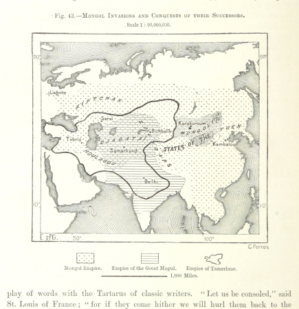
maps of the mongol empire
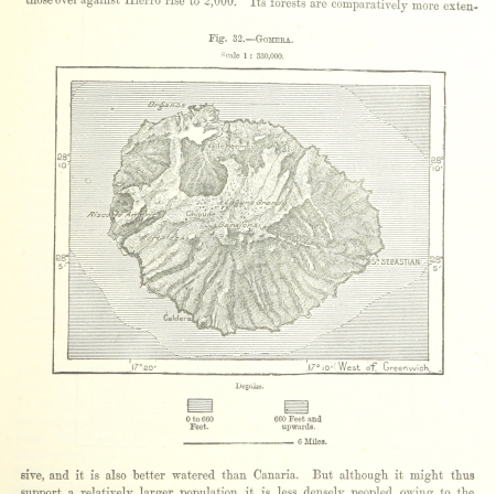
old maps of la gomera
1878 maps of spain
maps from the earth and its inhabitants, vol. v
1870s maps of russia
maps from the earth and its inhabitants, vol. xvi
1870s maps of panama
maps from the earth and its inhabitants, vol. ix
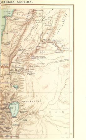
1870s maps of jerusalem
maps from the earth and its inhabitants, vol. ix
1870s maps of jerusalem
maps from the earth and its inhabitants, vol. iii
1870s maps of belgium
maps from the earth and its inhabitants, vol. viii
1870s maps of india
maps from the earth and its inhabitants, vol. iv
topographic maps of ireland
maps from the earth and its inhabitants, vol. xii
19th-century maps of senegal
maps from the earth and its inhabitants, vol. viii
1870s maps of india
truscott map of st-petersburg 1753
engraved maps of saint petersburg
maps in the staats- und universitätsbibliothek hamburg
1670s maps of hamburg
maps in the staats- und universitätsbibliothek hamburg
1670s maps of hamburg
merian mainz trier köln
baroque
eran laor cartographic collection
john cary
maps of haarlemmerhout
old maps of haarlem
1700s maps of the world
le neptune francois
1700s maps of the world
le neptune francois
maps from the earth and its inhabitants, vol. xiii
exploration of africa
1501 - 1600 of 10,904
Next page
/ 110